A park name that includes the nickname Sloppy? Of course we just had to come here. Once here, we started learning about the mining for marble that happened in this part of Georgia in the 1920s. The full history of this mining is in the next post along with our hike to one of the mining locations. In this post we’ll look at the history of the park, the 2 lakes with trails around them, and our campsite.
Welcome to James H. Floyd State Park in the mountains of northwest Georgia.
history of the park
From 1966 to 1973, this area was operated as a public fishing area under the Georgia Wildlife Resources Division before it became Chattooga Twin Lakes State Park in July 1973. After the death of local state representative James H. “Sloppy” Floyd in 1974, the park was dedicated to him in honor of his accomplishments for the state. In 1996, around 275 additional acres were purchased from Georgia Marble through the governor’s Preservation 2000 program that expanded the park’s border to the USFS Chattahoochee National Fores.
The 2 lakes at this park offer excellent fishing and boating opportunities, and trails offer mild to moderate hiking. Campsites and cottages are available for overnight accommodations. This is a beautiful park.
why “Sloppy”?
“Sloppy” was about 5’5″ tall in high school and was very robust. His football coach gave him the nickname of “Sloppy” because of how he looked in his football uniform since only the largest ones were available for his girth but were way too big for his height. He was known by this nickname for the rest of his life. He must have had a great sense of humor.
“Sloppy” as an adult; a nice looking man.
This map of the park highlights the 2 lakes that connect with the road through the park. Each lake has a walking path around it. The lake on the right is the Upper Lake, and the lake on the left is the Lower Lake.
Both lakes started out as holes in the ground where mining was done. Eventually, after the mining was done, the holes filled in with water, lakes were stocked with fish, and a dam in the Lower Lake kept the water in the lake. Streams and creeks from the mountain keeps emptying out into the Upper Lake.
In the next post, we’ll take you on the Marble Mine Trail (orange dotted trail in the bottom right corner) that goes to the open area where they mined in the 1920s and then the approach to the Pinhoti Trail (white dotted trail in the far lower right corner).
Upper Lake Trail
Our first view of this end of the 18-acre lake was from the road running through the park that separates the 2 lakes.
This bridge across the lake makes it easier to get to the trail around the largest part of the lake instead of having to start out at the day-use area of the park.
Our destination is a trail to the right through the trees in the distance.
Such a helpful bridge for boaters and those who love to fish. The boat ramp is at the far bottom right of this picture.
view of the lake from the bridge
We did see these special nesting boxes as we walked around the lake.
We think we saw some of these bass as we walked along the lake.
We saw signs for these yellow-bellied slider turtles at Magnolia Springs State Park.
We didn’t see any of these majestic birds on our walk.
As we walked off the bridge, we saw these local people fishing along the banks of the lake. They didn’t have much luck fishing today.
Wonder if we’ll see any of these deer in the park?
Now onto the trail. You’ll see some of the back county trail in the next post.
In the distance is the road through the park.
The trail took us toward the narrow part of the lake where a stream fed into the lake.
This stream that comes from the mountain keeps the water fresh in the lake.
As we walked back toward the center of the park where the 2 lakes meet, we saw these familiar orange barrels that are being used to keep vehicles from parking along the side of the road. Barney says that these orange barrels are Georgia’s third crop after peanuts and peaches since we see so many of them all over the state.
The bridge on the road over the water is where excess water runs out of this lake into the other one.
A close-up look at water spilling out of the lake.
Lower Lake Trail
This 2nd lake is 32-acres, almost twice the size of the Upper Lake. Even on this day in the middle of the week, numerous people were fishing from the shore and from boats on the lake.
This spillway allows the excess water to come into this 2nd lake.
Such a beautiful lake.
Beginning of the lake trail that starts at the road and ends up on the other side at the park’s office.
view across the lake
We knew that a trail from about this halfway point along the trail leads back to our campground. We kept looking for this trail so we could use it for going home but never saw a sign. We did see this trail on the left but thought it was for a half circle to meet up with our trail past this bridge.
our first look at the dam at the end of the lake
As we got closer to the dam, we saw this beautiful view of the lake.
When we got to the top of the grassy dam, we saw this view of the lake with the mountains behind it. The sun on the water just sparkles.
Looking back, we got a good view of the grassy dam.
For those of you who love to fish, here are the fishing regulations at this state park. What interested me is the last species; the grass carp, or white amur, must be released immediately. I wondered why?
Information nearby had the reason for releasing it immediately: it’s for vegetation control in the lake. Good to know.
This side of the lake was for group camping in the Pioneer Camping Area.
Here are some of the open cabins for pioneer camping for groups.
When we got to the park office, we talked to one of the staff members about the trail back to our campground. He said that it started at the bridge, so we walked across the bridge between the 2 lakes and started the trail again until we got to this spot.
We started off on the other trail that we pointed out to you, and sure enough, it was a trail that went up the hill.
Here’s part of this trail to our campground.
At this point in the trail, we saw the fork to the cabins so we walked toward them to check out this place to stay in the park.
This is 1 of the 4 lovely cabins/cottages in this part of the park.
This side view shows an outside entry to back porch.
When we got back to our campground, we looked at where we had been to show you the trail to the lake.
Blueberry Thicket Nature Trail
This short trail cuts through the lower end of the circular campground from the last campsite #25 to our campsite #1.
beginning of the trail—didn’t see any blueberries though
end of the trail was at our campsite
Remember the sign for the white-tailed deer we saw as we crossed the park’s bridge? Well, early in the morning this mama and her baby came to visit.
Since our campsite was the first one along the one-way road, we’re probably only ones who got to see these deer.
Here’s the mama keeping an eye on her baby across the road.
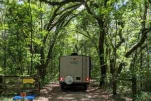
our campsite
In our first state park of this 3-state park trip, we mentioned that we had bought and were starting to use a cell booster. In the first 2 parks we couldn’t see much of a difference with the booster, but this park was different. When we first pulled in and set up, we didn’t even have even one bar of cell coverage. My initial thought was that we wouldn’t be staying here very long if I can’t keep up with what’s going on in the world, but I didn’t say anything to Barney about my discouragement.
Then Barney set up the cell booster, and voila! We got enough bars for some LTE and for our hotspot. We’re connected!
This is a nice campsite, but look how close the trees are to where we’re set up.
Nice setup, right? We even built a fire one night so I could roast some marshmallows.
Trees are right up next to us at our campsite while we were sitting in our chairs looking out.
Just beyond these trees is another campsite. The road is on the left.
Why did we talk about the trees being so close? After 4 days here, I was getting claustrophobic. Barney mentioned that he was getting a little bored, and I agreed with him. We had planned on a stay at a Harvest Host location on our way home, so found a 2nd location so we could take off a day earlier from the park and start exercising our minds a little more.
What’s Harvest Host? It’s a membership group for RVers that connects travelers while on the road with businesses that have large parking lots or unused flat lands were travelers can boondock (no hookups) overnight for free. The site only asks that we spend a little money in the businesses store as a thank you. Such locations are wineries, farms, breweries, museums, and golf courses.
After our next post about our hike to the marble mine, we’re off to the 2 Harvest Host locations!