If you’re from California, you’ve probably heard of Mono Lake but may not know its history or its significance. If you’re not from California, this information today may be totally new to you! Mono Lake is one of the oldest lakes in the western hemisphere and is described as “hauntingly beautiful” in one of our brochures. Today it’s known for its eerie tufa towers (mineral structures created when fresh-water springs bubble up through the lake’s alkaline waters). The lake is also known because we almost lost it when Los Angeles wanted more water.
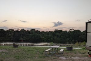
our first view of Mono Lake – it’s huge, even now
Mono Lake is at the western edge of the Great Basin, which covers 1/5 of the Western United States. Water from here never flows to the ocean and can only escape by evaporation, leaving salt and other minerals behind.
east from here across Nevada and a little north is the Great Salt Lake in Utah, a sister lake to Mono Lake
So here’s the story of Los Angeles wanting/needing more water.
In 1941 the city expanded its aqueduct system into Mono Basin by diverting water from 4 of the 6 mountain streams that fed the lake. Without this fresh water, the lake lost more to evaporation than it gained from inflow, and Mono Lake shrank to half of its volume over the next 40 years. Dust storms from exposed lake bottom created problems. In 1978 the state courts ruled for Mono Lake.
Decision was made in 1994 that the lake must be raised to a specific elevation, which you’ll see as we walk on to the edge of the lake.
These tufa towers form when freshwater from springs rich in calcium bubble up through the carbonate-rich lake water. The calcium and carbonates react to form a calcium-carbonate salt deposit that is called tufa.
These tufa were growing years ago when this area was covered by water before the levels started going down after 1941.
how water makes rock; it feels hard as rock but guess it’s really fragile
mandated lake level
When the lake reaches its mandated level of 6392 feet, this sign will be at the water’s edge.
And this wooded walkway will be under water. Look at how far away the lake is. It’s going to have to come up quite a bit to reach this level.
Barney at the edge of the lake; it is so green
I can attest that the lake is salty and bitter. Can’t attest to its buoyancy.
when the lake reaches its mandated level, this sign about brine shrimp will be under water
Brine shrimp don’t survive the winter so they have to prepare for the next generation. They are at the low end of the food pyramid.
tufa along the walkway as we were walking back to the parking lot
water is always moving beneath our feet; couldn’t see any springs emerging
glaciers from years ago – for those of you who are fascinated by geology and what happened thousands of years ago
parts of the Eastern Sierra rangefront fault system
Sierra Nevada rises nearly 2 miles over the town of Lone Pine in southern Owens Valley (we’ve been there!). System of faults along the Eastern Sierra produce dramatic differences in elevations. The Sierra Nevada is relatively young with most of its uplift occurring over the last 5 million years. Potential for new growth remains. Amazing!
what the glacier probably looked like in past Ice Age and carved out the canyons along the Eastern Sierra
Lots of different ice ages have occurred over thousands of years during the last 2 million years. These massive, slow-moving rivers of ice carved jagged peaks and deep valleys from solid rock and deposited mounds of eroded rock and debris. The question isn’t if the next glacial period will come but when since sunspots and changing cycles of the earth’s orbit affects more than whatever humans can do
A tremendous blast over 760,000 years ago created the Long Valley eruption, one of the largest in recent geologic history. It spewed more than 150 cubic miles of lava and ash into the air, and ash fell over much of the present day United States, circling the earth for years in the upper reaches of the atmosphere. The earth did recover, and here we are today
the area we looked at after we read the last sign
A little ways down the road we came across this sign about Mono Craters and this view of what spewed out of the crater from the volcano. When the craters began to form during the ice age, they created a chain of volcanic mountains. This basin was cover by ancient Lake Russell; Mono Lake is a remnant of Lake Russell.
I feel so young in comparison to these ancient lakes and mountains. Good to know.