Hopewell Rocks at the north end of the Bay of Fundy in Hopewell Cove used to be a Provincial Park but is now privately run—and it is run well. Two trips are required to take in the full picture of the area: high tide and low tide. We were here twice for each view, but I’ll combine them in this post for ease of reading.
Welcome!
This lovely flower area greeted us as we walked in. See the flags in the distance? Yes, it’s windy.
Here’s a good description of the movement of the tides here. If you’re the kind of person who like more details, go to the end of the post for the ins and outs of the tides, how this phenomenon came to be, and lots more information.
At low tide visitors can walk on the ocean floor and explore the rocks close up, which we’ll be doing! At high tide visitors can view some of the world’s highest tides as they surge up the bay.
Diamond Rockview
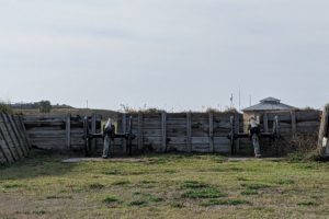
This was the first lookout deck we came to while we were walking the 1/4 mile to the high (and low) point of Hopewell Rocks.
entrance to Diamond Rock viewing deck
Off to our right as we were standing on this deck is Daniels Flats, an immense mud flat that is 4 km wide and stretches as far as Grindstone Island (in the distance) that had a grindstone quarry on it in the 1800s.
Daniels Flats
I didn’t get a high tide picture since it’s just water, so we’re giving you 2 low tide views. This view is closest to land.
And this view looks out at the mud flats.
Off to the left is this small cove.
the look at high tide
At low tide people are walking around, and the gap between the 2 rocks is so much bigger.
Big Coveview
This 2nd stop gave us some more amazing views.
entrance to Big Cove viewing deck
Sean is our tour guide during the morning walk to see the bay at high tide. He slowed us down enough so we could really “see.” Otherwise, we (I) would tend to snap some photos and walk to the next stop.
Off to the right is this cove.
high tide view of the cove
and low tide view of the same cove
Flower Pot Rocks view
This is the our destination. Can’t wait to see this part of the bay at low tide! But high tide first.
beginning of the stairs to walk down
But first some information on what we’ll be seeing.
The rocks we’ll be seeing have been formed over thousands of years from erosion from tides, snow, ice, and winds.
But the cliffs actually started forming about “330 million years ago when fast-flowing streams deposited thick layers of sand and gravel at Hopewell Cape from the nearby Caledonia Mountains. Over time these layers compacted into layers of conglomerate rock and sandstone. Forces from within the earth thrust and tilted the rock layers, creating large, vertical and horizontal fractures. These cracks were further sculpted by erosion to create the works of art now found upon the shoreline.”
Now to these “fractures.”
view at high tide from the top of the stairs
our view as we started walking down the stairs to the next landing
When we got as low as we could get on the stairs, here’s what we saw.
See, we couldn’t walk any lower at high tide.
And here are the views when we came back at low tide.
View from top of the stairs—looks so different!
And we kept walking down.
Now you can see the 3 levels of stairs we walked down before we got to the ocean floor.
clefts in the rock
And this rock looked small when we were looking down at it!
cliffs are so high
Our view looking out to the bay. See those people sitting on the rocks?
Now we’re looking into the Big Cove area that we saw from the 2nd lookout deck. We walked on a ways and then started walking back.
an individual rock
close up
1st look at this famous formation
2nd look
3rd look showing Nova Scotia way in the distance
More of the flower pots
Just as we were ready to retake the stairs, we met Buzz and Karen from Columbia, South Carolina. We walked with them all the way to the visitors center and enjoyed hearing about their lives. Karen is my hero since she loves to camp in a tent. Not my style, but I admire any woman who not only will put up with sleeping that way, but chooses to do so.
As we left, we saw this sign that we liked: Hopewell Rocks is where we can walk on the ocean floor.
Now to all kinds of background information on the Bay of Fundy that we saw in the visitors center. Since I’m not a science-type of person, my descriptions are in terms that I can understand.
This post is our last look at the Bay of Fundy until we get to Nova Scotia.
the rocks
This is one of the rocks we saw; now how did it get there?
Many of these rocks on the beach are as high as 100 feet, while others are only 60 to 70 feet tall. On the tops of many rocks are single trees that are still growing.
how these rocks formed
Let’s look at how these rocks were formed.
They were formed from sand, mud, and rocks eroded by rain, streams, and glaciers. Over millions of years, sediment accumulated and compressed to form 2 types of solid rock.
The harder of the rocks was formed by stones and pebbles cemented into place by hardened silt (conglomerate). The other, softer rock, was formed by layers of compressed sand (sandstone). As the earth’s continent moved and collided, these layers were tilted and broken. Cracks appeared, providing openings where water and ice could enter.
From right to left, bottom to top, these are the changes over the years on the edge of the cliffs ending with what we see in the top left corner.
Close up of the current look. Recognize the cove with this opening?
continental drift
let’s look at what this big picture is telling us.
After Pangaea (a supercontinent billions of years ago during the late Paleozoic and early Mesozoic eras) broke up about 175 million years ago, North American and European continents separated, creating a gap. As this gap grew, it filled with water and became the Atlantic Ocean.
With the rise in sea levels (around 6000 years ago), water flowed over the submerged Georges Bank (formerly a dry plain), and flooded the depression we know as the Bay of Fundy!
Now that we’re looking so far back in time, let’s look at how the Earth changed over millions of years knowing where Hopewell Rocks is.
180 million years ago
135 million years ago
65 million years ago
today!
Amazing to see how our planet has changed.
what’s swimming in the bay
At least 17 species of whales visit the Bay of Fundy. The sheer number of whales during the summer makes this a great place to come to for whale watching.
The most endangered of the whales is the North Atlantic right whale that we saw in the New Brunswick Museum in Saint John. It’s the rarest of the world’s large whales.
They come here to nurse their young and feed on huge amounts of krill, herring, and other fish.
Whales 1 and 2 are on the far left, 3 is the largest whale, 4 is in the middle, 5 is the far right, and 6 is under the largest whale.
1 is the North Atlantic right whale, 2 is the Humpback whale.
3 is the Finback whale (the 2nd largest marine mammal after the Blue whale, which can swim in many of the world’s major oceans), and 4 is the Minke whale.
5 is the Harbor (or Common) porpoise, and 6 is the Atlantic white-sided dolphin
mastodons from long ago
Remember the mastodons from some 70,000 years ago that we learned about in the NB Museum in Saint John? Here’s some more information.
The Hillsborough Mastodon, an ancestor of today’s elephants, was actually a young adult. It probably stood about 9 feet tall at the shoulders and would have weighed upward of 8 tons. Surviving for almost 3 million years, they didn’t become extinct until about 10,000 years ago.
causes of the tides
Think of 100 billion tons of water pouring into the bay twice daily—that’s like the average 24-hour flow of all the rivers in the world! That’s enough to raise and lower the water level by nearly 6 feet per hour.
Tides are caused primarily by the pull of the moon, but also by the sun, across the diameter of the earth. As the earth turns, the changes in gravitational force causes the tides.
Here at Hopewell Rocks, the tides rise and fall an average of 33 to 46 feet.
Tide times change each day because it takes 24 hours and 50 minutes for the earth to make 1 full rotation. The time between high and low tide is approximately 6 hours and 13 minutes (1/4 of the full rotation time). Therefore at any given point, the high tide is 50 minutes later each successive day.
Is your mind swimming? Mine is. So much to learn about our world.