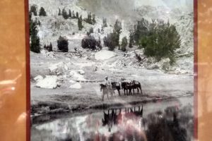
We started talking about wagon trains when we were in the Carson Valley area in the previous “Other Side” posts, especially in Genoa. At Fallon, our first stop along Hwy. 50, we learned so much more because this is where the wagon trains came through on their way to the Sierras. This silhouette welcomed us to Fallon and our start of Hwy. 50 (we visited Carson City on a previous trip to see family in Truckee so didn’t start our trip there).

Route
Travel by wagon train occurred primarily between the 1840s to 1880s, dropping off when the transcontinental railroad was completed in 1869. Most wagon trains started at Independence, Missouri, following the Missouri River to the Platte River. Even though the word “train” is used, when possible the wagons traveled next to each other instead of behind one another to keep the dust down.
Around Salt Lake City, the trails split as travelers wanted to go to different destinations, but the trail we’re following is the California Trail because these men and women were going after California gold that was discovered in 1849.

Mountain men who had probed the country between the Rockies and the Sierras realized that the region was a vast, bowl-like depression—a basin. Within this basin were hundreds of north/south mountain ranges separated by broad valleys of sagebrush, greasewood, and saltbrush. They called it a barren country, a country of starvation. We called it beautiful as we drove along.
When the wagon trains split at Salt Lake City to different destinations, the emigrants continued to follow the rivers. In the Great Basin, since its streams run north and south, parallel to the mountain ranges, the travelers needed a different route. The only river to go in their direction across the northern part of Nevada is the Humboldt. Early trappers knew about this river, and John C. Fremont even changed its name from Mary’s River to Humboldt River in 1845. The first California-bound overland emigrants followed the Humboldt River across the Great Basin in 1841, while most used a wagon trail blazed in 1843 by mountain man Joseph Rutherford Walker to get across desert from Salt Lake City and approach the headwaters of the Humboldt River.
The Humboldt twists and meanders along countless looping turns called oxbows because the route resembled the wooden yokes on their oxen. Although the river actually spans about 300 land miles, a twig drifting downstream between Humboldt Wells and the Humboldt Sink would easily travel twice that distance.
In the fall of 1845, John C. Fremont described the river valley as “beautifully covered with blue grass, herd grass, clover, and other nutritious grasses.” Cottonwood trees grew along the river banks. But in 1849, just after the gold rush started, some 21,000 people and 50,000 head of livestock had tramped and camped along the river. Tens of thousands more travelers followed over the next few years. All of the campfires, hungry mouths, and heavy hooves stripped the land of vegetation and compacted the earth. Wagons left behind, as well as other debris, cluttered the valley. Dead animals and their waste ruined the river and made the air hard to breath.
Later emigrants found that following this river wasn’t as pleasant as Fremont described it, but at least they had a direction to go in.
last chance to rest
As the Humboldt River ran its course, it spread out in one last green flourish of sloughs and marshes that the emigrants called Big Meadows. Today the community of Lovelock is at the north end of this area (see map).


Travelers would stay here for many days to rest and strengthen their cattle, and several hundred wagons might be here at any one time. As the draft animals grazed, emigrants cut hay for the horrible desert crossing ahead, and cleared out their wagons one more time to lighten their load.
40-mile desert

This was a horrible trip across the desert. No shade was available, and a crust of salt and silt crunched beneath their feet. Ironically, this area once lay at the bottom of a deep ice age lake that covered much of western Nevada. Lake Lahontan’s ancient shorelines are etched into nearby mountainsides 500 feet or more above the desert floor. (We’ll see more about this in a later post.) In the 1800s, however, this was a dry lake bed, churned by hooves and wheels into clouds of dust that choked both the emigrants and their animals.
The travelers would often start walking at night before the sun pounded down on them during the day. On moonless nights, they set fire to abandoned wagons along the trail to light their way. Death permeate the air from dead oxen, mules, and horses.
As they neared the end of the desert and their start of the Carson River, animals smelled the scent of water and tried to run the last few miles through the sand; not a good idea. In 1850, California miners donated funds to create relief stations in the desert, and in 1852, the California legislature set up at least 4 government relief stations to help emigrants along.
Where the emigrants found the fresh water of the Carson River, traders erected a tent city in 1854 known as Ragtown where travelers could buy provisions they desperately needed (usually at high prices). Of course, fresh water, grass, and shade were free.


We drove along the Carson River from Ragtown for a couple of miles. The cottonwood trees still are along the banks, and we found these beautiful mules enjoying their day. As soon as we stopped to take their picture, they started walking toward the fence to us. Probably wanted something to eat.

This access to fresh water at Ragtown didn’t last long for the Carson River route travelers. After this spot, the trail had some long, dry cutoffs between the broad bends of the Carson River, and the emigrants found some more deserts to cross. Some emigrants claimed that these crossings, even though shorter, were more severe than the 40-Mile Desert.
In 1857, one of the trails passed by Buckland’s Station on the Carson River; it was a ranch, saloon, and hotel for visitors on their way to California.

Buckland’s is at the junction of the Carson Route and the Central Overland Trail used by the Pony Express. More about this in the Pony Express blog.
summary of Great Basin changes
The start of the emigrants coming through this area was in 1841 with the Bidwell-Bartleson party. Its end came in 1869 when the transcontinental railroad took over transporting people. The early travelers had to be self-reliant, and the most difficult years were from 1849 (gold rush) through 1852 when tens of thousands of people surged along the Humboldt River for the gold fields and its riches. By the late 1850s, trading posts, ranches, and mining settlements dotted the trail. By the early 1860s, the Pony Express, stage lines, and the telegraph were in full swing. The “country of starvation” was becoming a land of enterprise and industry.
However, the changes that white settlers saw as progress were traumatic for the original people of the land who were forced to adapt almost overnight to new technologies, foods, languages, customs, and strange notions of wealth and land ownership. What these people had developed over 12,000 years disappeared within a single generation. Some tribes adapted easily, others fought the process. Today the tribes are alive and well, living in this modern world but still keeping their traditions alive.
Thanks to the National Park Service for its Auto Tour Route Interpretive Guide Across Nevada that provided much of this information. Pictures are from Fallon’s local museum.


